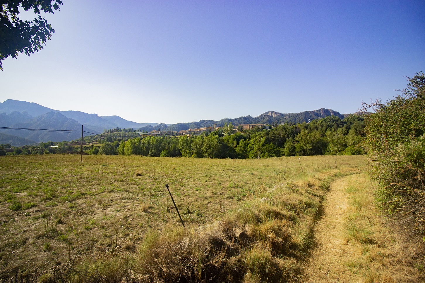
13. Apple trees
Published
ROUTE N. 13
![]() Difficulty: easy
Difficulty: easy
![]() Without technical difficulty
Without technical difficulty
Apple trees route is a family route of 3.5 kilometres that will let you know the nearest surroundings of Sant Llorenç de Morunys. It recovers the old path which connected Sant Llorenç de Morunys with La Coma in the past, and it lets us to visit cultural places such the Romanesque bridge of Vallonga or the hermitage of Santa Creu dels Ollers and also the different apple trees plantations located in some fields near the village. A perfect circular route to do it with kids or if you want to do a little hike through the surroundings of Sant Llorenç.
More information about the route
Type: circular route
Time: 55 min
Cumulative elevation gain: 86 m
1. La Creueta
Published
ROUTE N.1
![]() Difficulty: very easy
Difficulty: very easy
Short duration route with start and end in the Tourist Office of la Vall de Lord. It surrounds the urban area of Sant Llorenç de Morunys, goes through barranc de les Salines and returns to the beginning.
![]()
More information about the route
Type: circular route
Time: 18 min
Cumulative elevation gain: 69 m
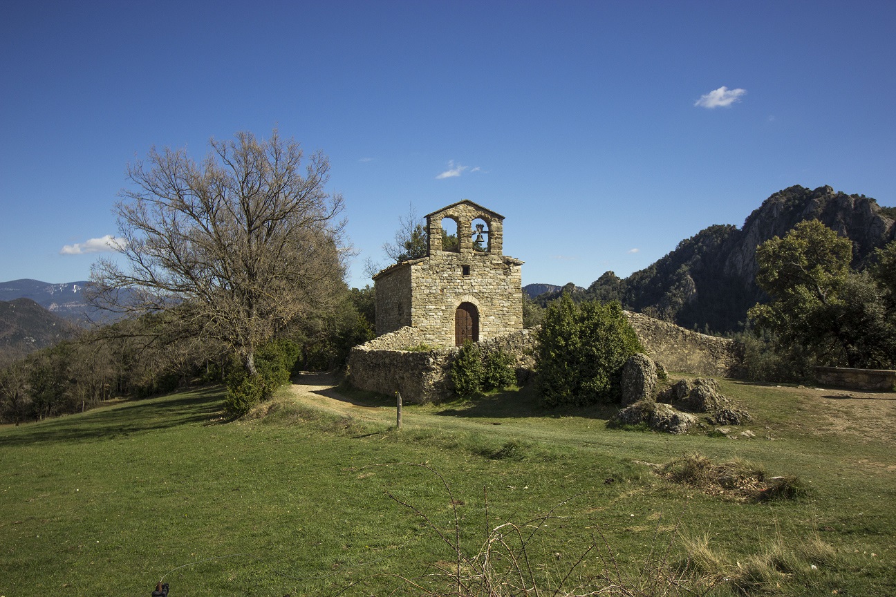
11. Chapels route (cultural route B)
Published
ROUTE N. 11
![]() Dificulty: very hard
Dificulty: very hard
![]() Without technical difficulty
Without technical difficulty
For the lovers of the cultural heritage and concretely the Romanesque heritage, this route goes by some hermitages of la Vall de Lord, most of them dated from the 11th century. About the different elements we can emphasise the church of la Pedra, one of the firsts to be built in the zone and located under the castle of la Pedra, now in ruins. Other patrimonial elements that we can find there are the hermitages of Sant Lleïr de Casabella, Santa Magdalena de les Tragines and Sant Cristòfol dels Pasqüets.

More information about the route
Type: circular route
Time: 4h 15 min
Cumulative elevation gain: 890 m
4. El Santuari
Published
ROUTE N. 4
![]() Difficulté easy
Difficulté easy
Route with start and end in the Tourist Office of la Vall de Lord. It’s a variation of the route Sallort that arrives at the foot of the Santuari de Lord.
![]()
More information about the route
Type: circular route
Time: 46 min
Cumulative elevation gain: 211 m
3. Els Torrents
Published
ROUTE N. 3
![]() Difficulty: easy
Difficulty: easy
Route with the start and the end at the Tourist Office of la Vall de Lord, ideal to families, it goes down the forests of the surroundings of Sant Llorenç de Morunys. It goes through the torrents of les Salines and les Valls, very close to the vigilance towers of la Torreta and Vilasaló.
![]()
More information about the route
Type: circular route
Temps: 31 min
Cumulative elevation gain: 154 m
2. Les Comes
Published
ROUTE N. 2
![]() Difficulty: easy
Difficulty: easy
Route that starts and ends at the Tourist Office of la Vall de Lord. It brings us to do a tour around the surrounding area of Sant Llorenç de Morunys until one of the tails of the reservoir of la Llosa del Cavall and then return.
![]()
More information about the route
Type: circular route
Time: 23 min
Cumulative elevation gain: 119 m
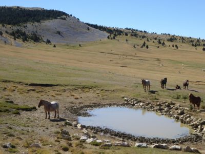
2. Walk through Bacies prairies
Published
ROUTE N. 2
![]() Difficulty: easy
Difficulty: easy
![]() Without technical difficulty
Without technical difficulty
This is an ideal route to do with the family. His flat grasslands formed by subalpine fields will let all the family members to enjoy the mountain in all its senses. Placed at 2100 m of altitude, the visitant will walk through the fields and the forests composed by creeping pines forests; at same time, the el Portet and l’Urdoll viewpoints will offer you an excellent views of Canalda and el Montnou area (Odèn).
The location of this route allows to do it in summer, by walking, or in winter, with snowshoes. In addition, it connects with other routes with different difficulties located in Port del Comte. Along the route you can find different explanatory boards about the flora and fauna of the area.
In winter, we advise precaution in the routes by vehicle to the starting points because of the presence of snow or ice on the road.
More information about the route
Type: circular route
Time: 55 min.
Cumulative elevation gain: 86 m.
Seasonality: you can do this route only during the months of spring-summer and autumn.
*It is recommended go by 4×4 or tall car to arrive at the starting point.
9. Vall de Lord green way
Published
ROUTE N. 9
![]() Difficulty: moderated (going and return)
Difficulty: moderated (going and return)
![]() Difficulty: easy (only going)
Difficulty: easy (only going)
![]() Without technical difficulty
Without technical difficulty
This lineal route goes from Sant Llorenç de Morunys to the point where Cardener’s river (Llobregat’s tributary) rises. In an almost 7,5 km tour (one-way) and a 400 m incline, this is an ideal route to do with kids from 10 years old.
The route will lets you discover different Vall de Lord’s cultural and natural elements while you are walking next to the river. The Vallonga’s Romanesque bridge, the Santa Creu dels Ollers’ Romanesque hermitage, the Puda source and the Cardener’s sources are some of the main attractions.
This is a route with low incline and with flat roads and paths so it is very recommendable for the families with kids.

More information about the route
Type: going and returning route
Time: 2h
Cumulative elevation gain: 234 m
6. Sanctuary de Lord by Vallonga hill
Published
ROUTE N. 6
![]() Difficulty: hard
Difficulty: hard
![]() Complicated terrain
Complicated terrain
![]() Pronounced slopes
Pronounced slopes
![]() Clamber
Clamber
A circular route with starting and ending point in Sant Llorenç de Morunys that goes by the old road to go to Santuari de Lord, from the 10th century. The route crosses Roc Foradat, a rocky formation with cliffs that let you pass to arrive at the sanctuary. To access to it there is a pavement path and once up you can enjoy a spectacular panoramic views. The return way goes by el camí de Sant Jaume and el grau de Sollort. The route turns off to Tossal de Vall-llonga and cingles de Malagana

More information about the route
Type: circular route
Time: 3h 40 min
Cumulative elevation gain: 744 m
6. El Jou
Published
ROUTE N. 6
![]() Difficulty: moderated
Difficulty: moderated
Route with start and end in the Tourist Office of la Vall de Lord. It’s a tour that goes close to the town of La Pedra and surrounds the hill of Jou. From el Jou we start the descent to el Monegal, combining tracks and paths enough technical.
![]()
More information about the route
Type: circular route
Time: 1h 56 min
Cumulative elevation gain: 691 m
7. Sallort
Published
ROUTE N. 7
![]() Difficulty: moderated
Difficulty: moderated
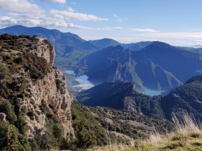
Route with the start and the end in the Tourist Office of la Vall de Lord. It arrives at la mola de Lord and does a turn in the southern part of this mountain, from where we can see the reservoir of la Llosa del Cavall
![]()
More information about the route
Type: circular route
Time: 1h 48 min
Cumulative elevation gain: 445 m
8. Pratformiu
Published
ROUTE N. 8
![]() Difficulty: very difficult
Difficulty: very difficult
Route with the start and the end in the Tourist Office of la Vall de Lord. It has high difficulty because of the ascent by very rocky paths with high slope. We can see the eroded terrain of Pratformiu and la Vall de Lord from the viewpoint of Cap de Balç.
![]()
More information about the route
Type: ruta circular
Time: 4h 17 min
Cumulative elevation gain: 1471 m
5. Les Fonts
Published
ROUTE N. 5
![]() Difficulty: moderated
Difficulty: moderated
Route with start and end in the Tourist Office of la Vall de Lord. It follows the most important springs of Sant Llorenç de Morunys, following the paths. We must emphasise the Font Puda (Puda spring), of sulphurous water.
![]()
More information about the route
Type: circular route
Time: 1h 7 min
Cumulative elevation gain: 322 m
9. La Bòfia
Published
ROUTE N. 9
![]() Difficulty: very difficult
Difficulty: very difficult
Route with the start and the end in the Tourist Office of la Vall de Lord. It has a high difficulty because of its high slope. It’s a high mountain route that follows part of the mountain range of Port del Comte. It arrives at the end of Prats de Bacies from where we can see great panoramic views and a landscape typical of field and forests of mountain pine. We recommend to visit the Bòfia hole, a very big deep natural well.
![]()
More information about the route
Type: circular route
Time: 3h 36 min
Cumulative elevation gain: 1353 m
5. From Sant Serni del Grau to sanctuary de Lord
Published
ROUTE N. 5
![]() Difficulty: moderated
Difficulty: moderated
![]() Pronounced slopes
Pronounced slopes
This route will let the visitants discover one of the most symbolic elements from the natural environment of Vall de Lord. It has 9 km of length and it starts at the hermitage of Sant Serni del Grau (dated from the 11th-12th centuries). This route consists in ascend to la Mola de Lord, place where the visitants will enjoy a fantastic views of La Llosa del Cavall’s reservoir, the Santuari de Lord and a canon, remain of the liberal-carlist conflict and placed at the arrival of la Mola.
Once at the top, you can descend by the known pathway of Sant Jaume (Saint James), where there is an obligated halt in la Trona’s viewpoint to enjoy the excellent views of the reservoir and Busa and Bastets mountain ranges.
If you want to reduce the length of the route you can go by car until grau de Lord, located at the foot of mola de Lord.
More information of the route
Type: circular route
Time: 2h 15 min.
Cumulative elevation gain: 362 m.
4. Viewpoint of Codó
Published
ROUTE N. 4
![]() Difficulty: easy
Difficulty: easy
![]() Without technical difficulty
Without technical difficulty
This route starts in Creu del Codó’s parking’s area, and Creu del Codó’s mountain range. This route can be done in the two direction ways and takes to Creu del Codó’s viewpoint, from where you can enjoy a great panoramic views. This route also passes into the picnic area located near to it.
Located at 1529 meters, this viewpoint is an ideal place to enjoy the views form the Vall de Lord. From it, it’s possible to see the town of Sant Llorenç de Morunys, the Busa and Bastets mountain ranges and the Llosa del Cavall’s reservoir. On clear days it’s possible to have an excellent views the Central area of Catalonia, being able to see the Montserrat’s mountain or Montseny.
In the starting and final points there is the leisure area of el Codó
More information about the route
Type: circular route
Time: 30 min
Cumulative elevation gain: 62 m

